Regional current models in your routes
On US coasts, on the European shelf and in the Mediterranean, routes sail by themselves in regional current models, tide included, and in SMOC around them.
In Puget Sound, in the Raz de Sein or in the Alderney Race, the current is mostly the tide, squeezed between headlands and islands: it can run at several knots through a narrows a few miles wide and lie slack in the bay beside it. A global ocean model, which sees the sea every 9 km or so, has only a few points of water in such a place and cannot draw the stream in detail. Yet in these waters, the hour you pass the narrows decides whether the boat makes good ground or hardly any. In the Strait of Gibraltar, the tide runs over the flow of the Atlantic into the Mediterranean, and the hour you pass changes what the stream gives.
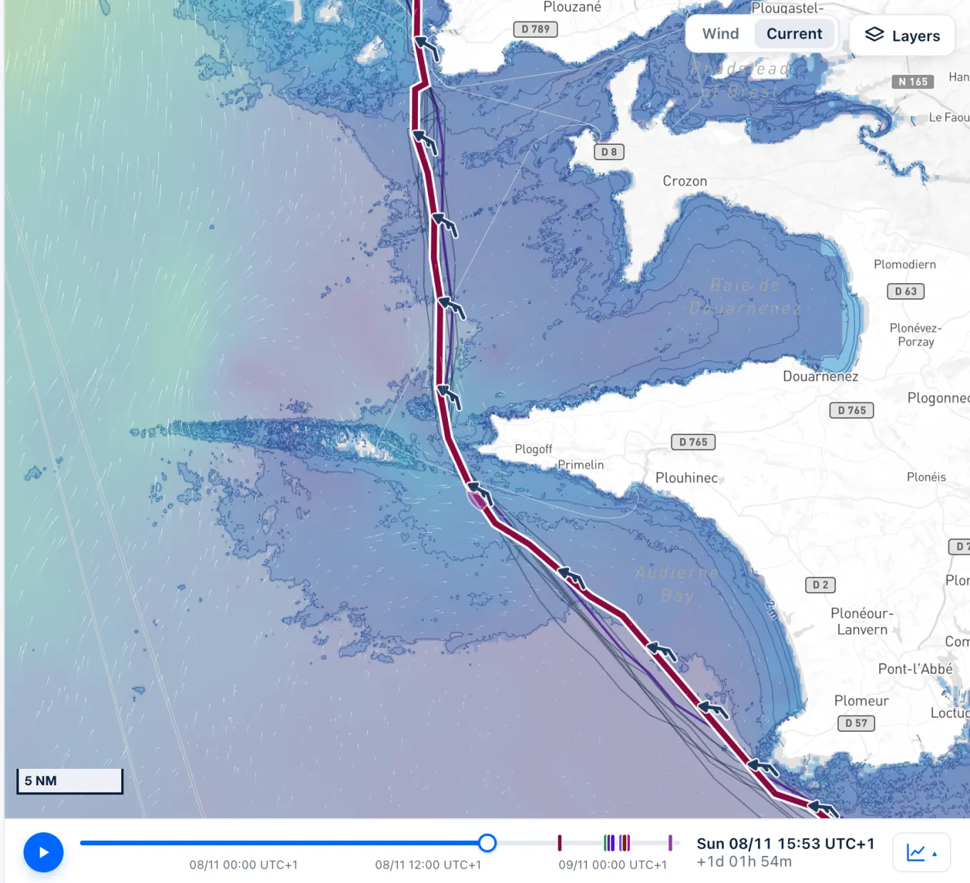
Regional current models draw these waters more finely, tide included. Routes now sail in them by themselves, with nothing to choose: wherever one of these models has water and covers the hour, the route takes its current, and everywhere else SMOC, the global current. The route's summary names each current it crossed, in order, for instance AMM15 then SMOC, the route log tells which one each leg sailed in, and the map shows the regional model's fine stream inside its waters.
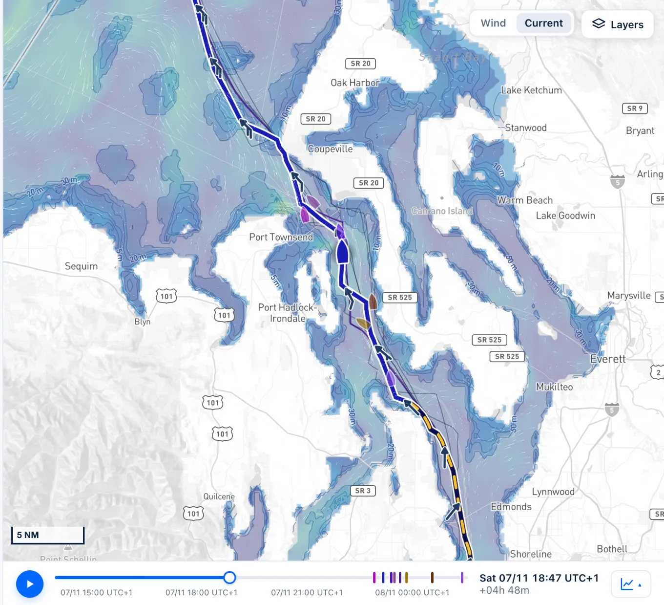
Three families are in. NOAA's Operational Forecast Systems, the OFS, cover eight US coastal areas: the Salish Sea and the Columbia River, Chesapeake Bay, Delaware Bay, Tampa Bay, San Francisco Bay, Cook Inlet in Alaska, the Gulf of Maine and the northern Gulf of Mexico, on grids about 250 m to 1 km fine, renewed four times a day, 48 to 72 hours ahead. AMM15, the UK Met Office's model, which Copernicus Marine distributes, covers the European shelf north of 46°N, the Channel, the North Sea, the Irish Sea and around Brittany, on a grid of about 1.5 by 2 km, renewed once a day, 7 days ahead. MedFS, the model of the Italian centre CMCC, which Copernicus Marine also distributes, covers the whole Mediterranean, the Strait of Gibraltar and an Atlantic box off Portugal, Galicia and the south of the Bay of Biscay, on a grid of about 4 km, renewed once a day, 10 days ahead.
Take Seattle to the San Juan Islands, through Admiralty Inlet, where NOAA predicts the stream at up to about 4.5 knots: reach it with the ebb running out of the Sound and it carries the boat through; a few hours later, the flood meets her at the narrows. Or take Yeu to Roscoff, round the west of Brittany: on the same wind, one route met 3.6 knots in the Raz de Sein in AMM15, against at most 2.4 anywhere on the way in SMOC alone. Or take Málaga to Cádiz, through the Strait of Gibraltar, where the surface water mostly runs in from the Atlantic, though the tide can turn it: on one forecast, the routes met up to about 2.5 knots running west in MedFS, and the strait, from Cape Spartel to Ceuta, gave them about 2 to 4 miles; leave six hours later, and it ranges from 3 or 4 miles gained to nothing or a little lost, according to the hour each one reaches it. Compute the passage for a few departure times and compare the arrival times and the miles the current gives or takes: you see which tide the model favours.
A regional model sees its own waters only. Close in along the shore, where its grid has no water, past its last hour and beyond its edge, at 46°N for AMM15 and 45.15°N in the Atlantic for MedFS, the route passes to the global current with no blending: plan a departure three days out, and Admiralty Inlet is SMOC's, so compare like with like; hold the Spanish shore from Trafalgar past Tarifa, where MedFS's grid has no water, and that stretch is SMOC's too. A narrows a mile wide is about one cell of AMM15's grid, and the Strait of Messina, under 2 miles at its narrowest, less than one of MedFS's: the stream there is not drawn. MedFS's hours are worked out from hourly means, which smooth a peak a little. On a very long passage, whose time step lasts hours, a strong tide counts for a whole leg and overstates what it gives. A route chases the stream, not the sea it raises: wind against tide in a tidal race stays your call. Saily WR has not compared these models with observations: in a tidal race or a narrows, your tidal atlas, your pilot book or NOAA's tidal current predictions remain the reference, and in a gale, the official warnings come first.
Sources
- Operational Forecast System, NOAA Center for Operational Oceanographic Products and Services (CO-OPS)
- NOAA Current Predictions, NOAA Center for Operational Oceanographic Products and Services (CO-OPS)
- Atlantic - European North West Shelf - Ocean Physics Analysis and Forecast, Copernicus Marine Service
- Product User Manual for MEDSEA_ANALYSISFORECAST_PHY_006_013, issue 2.5, Copernicus Marine Service