How weather routing works
A boat, a forecast and a method older than computers: how a router finds the fastest route across the sea, by the rules of the art.
The straight line is rarely the fastest way across the sea. A sailing boat makes no way head to wind, flies on a reach and wallows dead downwind in a light breeze, and the wind it will meet changes from mile to mile and from hour to hour. Choosing a heading for the next ten minutes is easy; choosing it for the next three days, knowing that every choice carries you into a different wind, is not. The question has a mathematical name. In 1931 the German mathematician Ernst Zermelo posed it for an airship crossing a wind that varies in space and time: which steering brings a craft from A to B in the least time? Weather routing is the practical answer to that question, worked out for ships and sailing boats over some seventy years.
Every router, from the navigator's chart table of the 1950s to the software of an ocean race, puts together the same three ingredients. The boat: how fast it sails in each wind, at each angle to it. The weather: the wind forecast over the whole area and the whole length of the passage. The sea: the current that carries the boat, the coast and the shallows it must keep clear of. To them it adds an objective, most often the earliest arrival, sometimes a safer or a more comfortable passage, and a method to search, among the countless tracks possible, for the one that best meets it. A route is only as good as its weakest ingredient: a perfect algorithm on a poor forecast draws a confident line to the wrong place.
The boat comes in as its polar: a table of speeds through the water for each true wind speed and each true wind angle, drawn as a fan of curves. The best are computed by a velocity prediction program, or VPP, such as the one the Offshore Racing Congress runs for every boat it rates: from the hull's lines, the rig and the sails measured, it looks for the speed at which the drive of the sails balances the drag of the hull, and their heeling moment the boat's righting moment, in winds from 6 to 20 knots, from close-hauled to dead downwind. Other polars are measured at sea, from the boat's instruments logged over seasons. From a polar come the angles a navigator lives by: the best angle to beat upwind or to run downwind, where the speed made good towards the wind or away from it, the VMG, peaks. A polar describes a boat well sailed, with the right sail up at every angle and its crew on the rail; a cruising boat laden for a passage rarely matches it, and navigators routinely route on a share of it.
The weather comes in as the files of a numerical model, most often in the GRIB format of the World Meteorological Organization: on a grid of points, a few kilometres apart for a regional model, about nine to thirty for a global one, the wind ten metres above the sea, given as its two components, west to east and south to north, every hour or every three hours up to the model's horizon. The boat is never on a point of the grid, nor at the time of a step: the router interpolates, in space between the points around it, in time between the steps around the instant. The method is simple, and it smooths. What happens between two points, a sea breeze in a bay, the wind accelerating off a cape, is not in the file and will not be in the route; nor are the gusts, since the field holds a mean wind, and the polar is read at it.
Before computers, routing was drawn by hand. In 1957 R. W. James, of the US Navy Hydrographic Office, published a method to steer ships clear of the heavy seas that wave forecasts had begun to predict: from the departure, mark how far the ship can go in a set time on each heading, join these points into a curve, then start again from that curve for the next interval. Each curve joins the points reachable at the same instant: an isochrone. When one of them touches the destination, the fastest route is found, and is traced back from curve to curve to the departure. The method was born for ships slowed by the waves, but it suits sailing boats just as well, whose speed depends on the wind as much as a ship's on the sea; nearly seventy years on, it remains the heart of most sailing routers.
A computer does the same, many times finer. From the departure it tries a fan of headings, every five or ten degrees all round; on each, it reads the wind at that place and that instant, finds the boat's speed in the polar, and moves the boat on for one time step, ten minutes or an hour. The points reached make up the first isochrone. From each of them it tries the fan again, and so on, step after step: the front spreads like a ripple on a pond, quickly where the boat sails fast, slowly where the wind fails, and it bends around a headland as a swell around a breakwater. The image is no coincidence: it is Huygens's principle for waves, every point of a front becoming the source of the next. When the front reaches the destination, the computer, which noted for each point the one it came from, follows that thread back to the departure: that thread is the route.
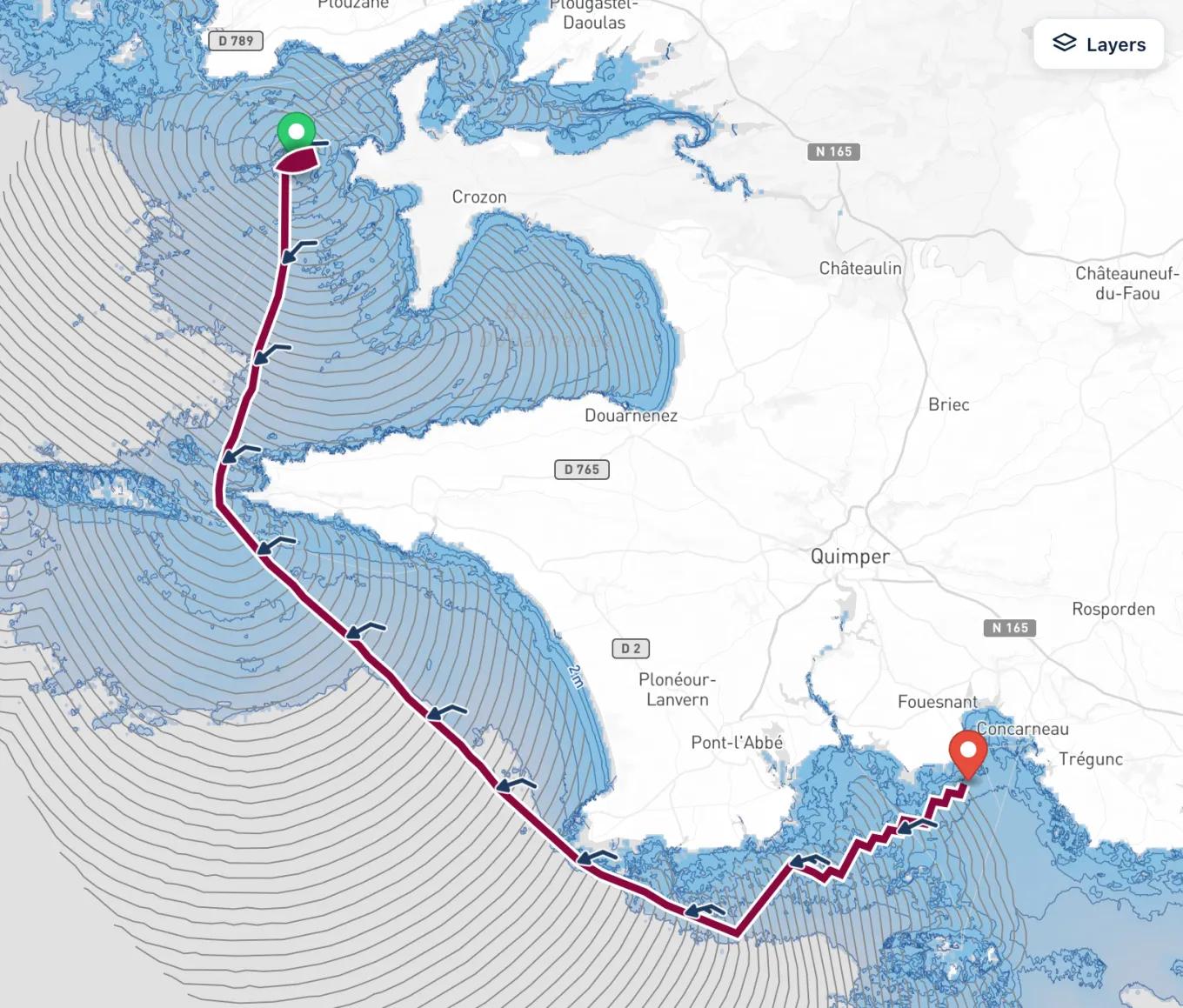
Left alone, the method would drown in its own points: thirty-six headings from each of thirty-six points already make 1,296 after two steps, and nearly 1.7 million after four. A router therefore prunes the front at every step, keeping only the points that may still lead somewhere. The classic way, which Hideki Hagiwara made fit for computers at Delft in the late 1980s, cuts the area around the departure into narrow sectors and keeps, in each, only the point farthest out; it also rids the original method of its loops, the front folding back on itself behind an obstacle. Other routers keep, in each cell of a grid laid over the sea, the point closest to the destination. The settings of this pruning, with the time step and the gap between headings, decide what a router can see: too coarse, and it cuts a channel short or misses a wind shift; too fine, and the computation grows long for a precision the forecast cannot justify.
The isochrones are not the only road. Laid over the sea as a mesh of points, the problem becomes a search for the shortest path in a graph, the kind that Dijkstra's algorithm, published in 1959, and its heir A* solve, or a problem of dynamic programming, solved stage by stage; ship routers use them to choose the speed as well as the track, and save fuel. The calculus of variations and optimal control, Zermelo's own road, write the best heading as an equation to be solved along the route: elegant, but fragile once land and shallows come in. Genetic and evolutionary algorithms breed and cross thousands of candidate routes to balance several objectives at once, time, fuel and safety. A review of these methods by researchers of the Fraunhofer centre for maritime logistics concludes that none wins in every case: the best depends on the objective, on what may be controlled, on the constraints and on the care taken in implementing it. For a sailing boat, whose one control is its heading, the isochrones remain the reference.
A current changes more than the speed over the ground. A boat sails in the wind it feels on the water, and in a current that wind is the forecast wind, which blows over the ground, less the current. Wind against tide, the breeze over the water freshens and the sea gets up; wind with the tide, it eases. A careful router therefore reads the polar at the wind over the water, which gives the boat's speed through the water, then adds the current as a vector to find where the boat goes over the ground. Ocean models such as those of Copernicus Marine or NOAA give the current on grids about nine kilometres wide: enough for the Gulf Stream or the Agulhas current, not for the stream of a narrow passage between two islands, where a tidal atlas or the official tidal stream predictions keep the last word.
The land is the hardest constraint, and the place where a router most often lies. A route must neither cross it nor run aground: each leg is checked against a coastline, or against a grid of depths with the draught and a margin. The finer the chart, the closer the route may follow the coast; on a coastline drawn to the kilometre, a channel closes and a headland offers a shortcut through its rocks. Depths are read at chart datum or at mean sea level, and the tide, which a static chart does not see, adds water above chart datum but may take it away below mean sea level. Then come the rules of the sea: traffic separation schemes, restricted areas and, in ocean races, the zones the race forbids, such as the exclusion zone the races round the world draw around Antarctica. A router that ignores them draws a track the skipper may not sail.
A polar knows nothing of manoeuvres, nor of the sea. A tack costs a racing crew a few seconds and a short-handed cruising crew several minutes; a gybe in a blow costs more, and carries a risk. Many routers charge each one a time, so that the route stops zigzagging for a gain of a few metres. A swell or a short chop slows a boat upwind far more than its polar says, and some routers lower the polar with the height of the sea. Safety, lastly, sets limits no time gained can justify: a wind not to sail in, a sea not to take on the beam, an angle not to hold dead downwind in a gale. Research calls this multi-criteria routing, weighing speed against safety and comfort; a skipper calls it seamanship.
The best route in a forecast is only as good as the forecast. The atmosphere is chaotic: two states that differ by almost nothing part after a few days, and a low forecast for Thursday may pass a hundred miles north or south. Forecasting centres measure that doubt with ensembles: ECMWF runs its model 51 times at each run, a control and 50 members whose starting point and physics are slightly altered, on a grid about nine kilometres wide. Routing every member gives, instead of one line, a bundle of routes: where they hold together the plan is sound, where they fan out the doubt is real, and the share of members on each option gives its odds. Comparing the routes of several models, each started from its own analysis, does the same in a cruder way. Repeating the route for every departure hour over several days, lastly, turns the routing into the choice of a weather window.
A route is a strategy, not a track to steer. The models run again every six or twelve hours, fed with fresh observations, and the next run may move the very low the route was built around: a good navigator routes again at every run, and watches how the route changes from one run to the next as closely as the route itself. At sea, the forecast is checked against what the boat meets: the barometer, the wind on the instruments, the wind over the sea measured from satellites by the scatterometers. When the wind met parts from the wind forecast, the model that saw it coming deserves more trust, and the route its wind draws more weight.
Reading a route well means knowing why it goes where it goes. The isochrones tell it: where they crowd together the boat makes slow progress, where they open out it makes fast, and a route bending far from the direct line goes looking for a wind or a current worth the extra miles. A route that turns upside down when the departure moves by an hour, or from one model to the next, rests on a fine balance between two options: the sound choice is often the one that loses little whatever happens, not the one that gains most if all goes to plan. And the most useful line on the chart is sometimes the escape: a harbour to run to if the front comes early.
Saily WR follows these rules, and says where it stops. It computes by the isochrone method: at each step it tries 36 headings, every 10°, the wind interpolated in space and time, the boat's speed read in its polar, chosen among about 22,400, ORC certificates included, and scaled by its performance. In each cell of a grid it keeps the point closest to the destination, and drops the cells an earlier step already reached, as a shortest-path search would; the time step follows from the trip's distance, for about a hundred isochrones, from one minute for a coastal race to six hours for an ocean crossing. In a current, SMOC or RTOFS, the polar is read at the wind over the water and the current carries the boat over the ground; each leg is checked against OpenStreetMap's coastline, or against the depths of EMODnet and GEBCO with the minimum depth you set, and in light airs the boat's engine can take over. Above all, rather than one forecast, it routes on each of its 21 models that covers the trip, side by side: where their routes agree the forecast is firm, where they part the doubt is real.
It does not yet do all the art knows. Its routes charge no time for a tack or a gybe, read the same polar whatever the sea, and cross traffic separation schemes and race zones as if they were not there. The gusts and the waves are shown along the route, never used to compute it. It routes no ensemble member and does not search for the best departure: to weigh a window, compute again an hour or a day later. Its depths hold no tide, and its currents, about nine kilometres wide, do not tell the stream of a narrow pass. None of this is hidden, and none of it replaces the skipper: a router finds the fastest route in a forecast, while the route to sail stays a seaman's decision, made with the chart, the barometer and the sky.
Sources
- Zermelo's navigation problem, Wikipedia
- Modeling and Optimization Algorithms in Ship Weather Routing, L. Walther, A. Rizvanolli, M. Wendebourg, C. Jahn, International Journal of e-Navigation and Maritime Economy, 2016
- Velocity Prediction Program (VPP), Offshore Racing Congress
- Medium-range forecasts, ECMWF